“I to the hills will lift mine eyes”

And when the hills look like these at the far end of Glen Arklet, there aren’t many better places to be!

Travelling north-west on the B829 from Aberfoyle in the Trossachs, you pass four very different lochs. There’s mighty Loch Ard, tiny Loch Dhu, slim-waisted Loch Chon – Loch of the Dogs – and Loch Arklet, lying at right angles to the rest. A short distance beyond the end of Loch Arklet you reach a T-junction and here you have the choice of turning left to Inversnaid on Loch Lomond, or right to Stronachlachar on Loch Katrine. Lochs galore to choose from!

Just short of that T-junction, we stopped to savour the view. Looking westwards along Glen Arklet, the snow-covered peaks of the Arrochar Alps rise to form a magnificent backdrop to the loch, which, like many a loch in the Highlands, is now part loch, part reservoir and linked to the hydro-electric scheme that changed life in the Highlands forever.

Then there’s the Rob Roy MacGregor connection – this is the Trossachs after all! Mid-way along Glen Arklet sits the tiny settlement of Corriearklet, and it was here, in January 1693, that Rob married Mary MacGregor of Comar.

Loch Arklet lies within the Loch Lomond and Trossachs National Park and on The Great Trossachs Path. There’s an excellent off-road walk from Stronachlachar to Inversnaid that runs the length of the glen. Parts of the route follow the tracks of old Statute Labour Roads and old Military Roads – so you really are walking through – and on – history!

And at both ends of the walk you’ll find food! Whether at the Inversnaid Hotel or the Inversnaid Bunkhouse to the west, or the Pier Cafe to the east at Stronachlachar.

It’s a wonderful part of the country and we are very fortunate to be able to enjoy this wild landscape. Returning from a day out, you realise just how much we benefit from spending time outdoors, especially among our hills and lochs. The natural world gives us so much, and for that I am truly thankful!

Old Ways through the Glens: Stoneymollen Coffin Road

We may not always realise it, but it’s surprising how often we’re following in the footsteps of General Wade or Thomas Telford when we travel around Scotland; particularly the further north we go. And though their roads were fairly basic, they were undoubtedly a great improvement on what went before, when the majority of people had no alternative but to walk and roads were virtually non-existent.

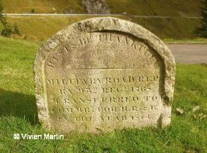
War, and then commerce, led to gradual infrastructure improvements in the 18th and early 19th centuries: initially under the military and General Wade, later Telford and the Highland Roads Commission. The stories of these two men and their achievements make for fascinating reading. Especially Thomas Telford, a Border Scot, who was the finest civil engineer of his day.  This is at the heart of my article in June’s edition of iScot magazine.

However, humans have always been on the move and, from necessity, have found ways to get about. And so the article also looks at drove roads, drowned roads, and one type of old road that served a very particuler function: coffin roads. Though I have to say right away that they weren’t ‘roads’ in the sense we understand them, rather narrow tracks or paths.

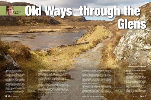
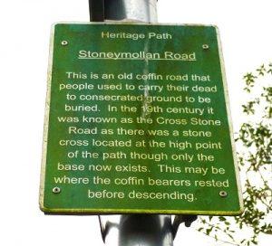
The Stoneymollan Road is a former coffin road that runs from Balloch, at the foot of Loch Lomond, to the burial ground at St Mahew’s Chapel in the clachan of Kirkton, not far from Cardross. In Medieval times only certain churches had burial rights and such churches were often few and far between. This was often as a result of the rugged, mountainous landscape of much of Scotland’s west coast, where for many centuries travelling by boat was an easier option than attempting to traverse the Highlands on foot. Consequently many of these early Christian settlements were to be found close to water, established by those determined missionary monks (think Columba onwards!) who plied the sea roads of the west, sailing among the islands and up long sea lochs such as Loch Long and Loch Fyne. This left many rural settlements remote from a church and so people were often faced with a long trek to the nearest cemetery. And the coffin had to be shouldered and carried the whole way!

Over time, numerous eerie superstitions became attached to these old tracks: the coffin must not touch the ground or the deceased’s spirit would return to haunt the living; the corpse’s feet must face away from their house or they could return to haunt their former home; the coffin bearers must not step off the path onto neighbouring farmland or the crops would be blighted; spirits liked to travel in straight lines, so the paths often meandered; spirits could not cross running water, so the paths crossed burns; you could lose a following spirit at a crossroad, so the route would have a crossroad!

The crumbling shell of Woodhall House

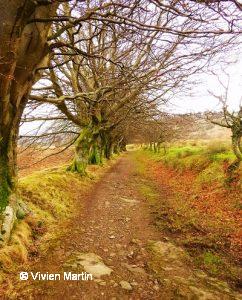
Today the old Stoneymollan Coffin Road is part of both the Three Lochs Way and the John Muir Way and links Loch Lomondside with the Firth of Clyde (and vice-versa). And the people you’re most likely to meet today will be walkers, joggers and even cyclists!

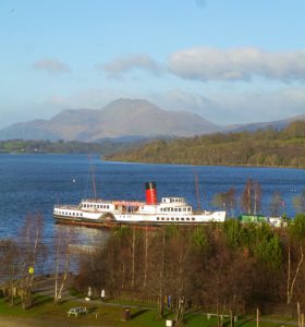
Setting off from Balloch we noticed the crumbling remains of Woodhall House, with an array of rusty iron gates, nearly invisible under shrubs and trees: almost like the hedge of thorns that grew up around Sleeping Beauty. This area used to be full of such grand houses even though the settlement at Balloch itself was small. But Balloch had its pier, and boats regularly plied the waters of Loch Lomond. Later came the railway, which for many years ran right up to the pier, until that spur was closed in 1986.

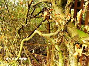
The hidden gates to Sleeping Beauty’s palace?

The track goes upwards and the higher the track, especially atop Stoneymollan Muir, the better the views back over Loch Lomond. When you reach the highest point a spectacular panorama opens up westwards, over towards Cowal and, if you’re lucky with the weather, sometimes even as far as Arran. There is a tremendous sense of space and openness on this track: a real sense of freedom.

Then it’s downhill all the way to St Mahew’s Chapel in Kirkton. This lovely old building was restored in the 1950s, but it’s history goes back to at least 1467, and it’s possible that there may have been a Christian missionary building on this site from the early sixth century onwards. For almost two centuries the building served as a school prior to its restoration, but the site was one that had long been held sacred, and is so again today.

When you come to Cardross at the end of the walk, you can take the bus or train back into Glasgow. While if you walk the route from Cardross to Balloch (ie west to east and sometimes easier in the prevailing westerly wind), you can likewise take the bus or train from Balloch back into town: but don’t forget to check the timetables. Alternatively get a friend to pick you up from whichever end you arrive at!

But watch out for any spirits that might just still be lingering along this old coffin road!

Monks, marauders and madmen

The fascinating tale of Inchmurrin’s exciting past is told in April’s iScot magazine

There’s something really rather appealing about alliteration, something that lends itself to article titles. They’re memorable. They’re snappy. They tell a little story of their own. Although it’s only an indication of what else there is to come: a taster of the treat that’s in store when you read the whole story. And if you haven’t visited Inchmurrin Island on Loch Lomond, then there is indeed a treat awaiting you!

An old sea dog!

It combines a boat trip, with good food and an island with a ruined castle to explore. Shades of an Enid Blyton adventure – but with grown ups! We tend to think of islands as being far away, out in the Atlantic or other great oceans. But here in Scotland we’re blessed with islands of every shape and size, some of them literally within minutes of our front doors. Yet despite being near at hand they’re still islands and that magical ferry trip, no matter how long or how short, makes them special. Loch Lomond is awash with islands. Twenty-two of them have names and Inchmurrin is the largest, not only on this loch but in any freshwater loch in Britain.

We were there recently with visitors over from Canada. The island ferry fetched us from the Burnfoot Jetty at Arden, just north of Balloch, and took us over to the island: though there are other ways to get there.

Looking up the loch from the ruins of 14th century Lennox Castle

The views up and down the loch on the short crossing are wonderful, and being in a small boat, sitting low in the water gives a real feeling of being at sea! Lunch was in the island restaurant, run by the Scott family, who own and farm the land and thanks to them guests are free to roam the island.

To the north-west lies mature woodland, especially alder and holly. To the south-west the ruins of the 14th century castle built by the Earls of Lennox when they fled the plague, abandoning their castle in Balloch. Although chiefly used as a hunting lodge, the castle nonetheless saw its fair share of murder and mayhem, and in the early 18th century was raided by Rob Roy during his lengthy conflict with the Marquis of Montrose. There was also a chapel dedicated to St Mirren – hence the island’s name.

Chirpy island residents

The island sits along the Highland Boundary fault line and is rich in history and archaeology and makes for a delightful day out. There’s a great deal more to tell, but as this is just a taster, I’ll stop now. Though the full article is available in this month’s excellent iScot magazine.

So if a day out on the water appeals, then head for Inchmurrin. And be glad that you don’t have to go far in Scotland to find an island!

Power and Beauty in the Glens: Loch Sloy Dam Part 1

It was freezing cold, with snow in the air and on the hills, and colder the higher we went. But, as so often when walking in Scotland, we knew the destination would be worth it. And that destination was the Loch Sloy dam, flanked by the mighty and rugged Ben Vorlich.

Parking at Inveruglas Visitor Centre on the west bank of Loch Lomond, we followed the signposts for Loch Sloy & Hills, which took us past the impressive Loch Sloy Hydro-Electric power station. Construction of the dam began in May 1945 and was the first in the North of Scotland Hydro-Electric Board’s revolutionary scheme. Work was completed in 1949 and the station officially ‘switched on’ in October 1950. The construction work was back-breaking and dangerous, with twenty-one men losing their lives in the process.

Loch Sloy Hydro-Electric station on Loch Lomond

The dramatic history of ‘Power from the Glens’ has long interested me. The water for this power station comes from Loch Sloy, high in the hills, with its massive dam, 56 metres high and 357 metres long. From here it is channelled through a 3km tunnel, hewn through of the massive side of Ben Vorlich. On reaching the valve house it thunders down through four mammoth pipes to drive the turbines below.  Such is the power of the water that the station can generate enough electricity to meet sudden peaks in demand, reaching full-capacity within 5 minutes of a standing start!

It’s a straightforward walk, a round-trip of 11km. When you reach the access road to the dam, walk under the railway bridge and then it’s up! And the higher you go, the better the views of Loch Lomond and the surrounding hills become. The construction of the Loch Sloy dam and power station was, quite literally, a groundbreaking start to one of the most progressive and far-reaching engineering projects in the world. So when you reach the dam, take a look at your map, and wonder at how it was possible, all those years ago, to carve such tunnels through these mountains. Some of the work force were even prisoners-of-war awaiting repatriation. In a booklet published by Scottish Hydro Electric, due credit is given to these men:

After the Second World War, men from all over Scotland came to work on the schemes, attracted by high wages. The highest wages were earned by the men who dug the tunnels. Germans, Poles and Czechs were acknowledged to be skilled tunnellers. They became known as the ‘Tunnel Tigers’ because of their cavalier approach to safety in their quest to earn the huge bonuses that were available. The lower regard for health and safety issues than there is today inevitably led to high accident rates and deaths amongst the workers. No definitive accident statistics exist, but in one camp alone, which housed some 1,000 workers at its peak, there were 22 deaths in just one year. For the vast majority of workers the rewards were great. In the late 1940s, a ‘Tunnel Tiger’ could expect to earn up to £35 a week, compared to £3 or £4 for a Highland estate worker. Mostly they lived in temporary work camps built near the construction sites. Not surprisingly, the sites looked like military camps, sometimes housing up to 3,000 men.”

The scheme was masterminded by Scottish politician Tom Johnston (1881-1965) and, under the auspices of the North of Scotland Hydro-Electric Scheme, succeeded in bringing power to the glens in a way never before imaginable. By 1963 90% of the Highlands were attached to the grid, more than twice as many as when the scheme began just after the Second World War. ‘Power from the Glens’ ultimately changed the face of rural Scotland and the benefits continue to this day.

Their achievements are all the more remarkable given the harsh conditions and often unforgiving terrain they had to work in, and we owe them a great deal. For not only is Scotland a country of great natural beauty, but it’s also one rich in natural resources. And so it’s doubly remarkable that Tom Johnston and his fellow visionaries harnessed hydro-power without damaging the landscape, and also left dams and power stations of great stature and beauty.

As renewable and sustainable energy become increasingly important, the hydro-power schemes these men bequeathed us become equally more significant. We need renewable energy like hydro-power: and in a country of rivers, lochs and plentiful rain, hydro-power is definitely here to stay!

Snow- and cloud-capped Ben Lomond from the road to Loch Sloy dam

Loch Lomond and The Trossachs National Park

Time out in the Trossachs 1: An Ceann Mòr on Loch Lomond

‘An Ceann Mòr’ or ‘The Great Headland’: the dramatic new pyramid-shaped viewing platform at Inveruglas on Loch Lomondside

Ask most people to name a place in Scotland that they’ve heard of and chances are they’ll come up with Loch Lomond and the Trossachs. What Walter Scott set in motion all those years ago with his poem The Lady of the Lake continues today. And with good reason. A National Park since 2002, Loch Lomond and the Trossachs is possibly one of the best-known areas of Scotland. Natural beauty, lochs and mountains, hills and glens –  the Park has them all: and a-plenty.

When the Scottish Government launched its first Scenic Routes competition, there was a wealth of entries. Young architects from all over submitted pland for special installations, designed to enchance particular areas in the Park. The four winning entries were duly built and have become popular and much-loved sites for visitors.

‘Stargate Loch Lomond’ – Loch Lomond’s very own pyramid!

It’s not often you associate the Scottish countryside with pyramids, but Loch Lomond now has a splendid one!  An Ceann Mòr, Gaelic for the Great Headland, is one of four installations that marked the inaugural Scottish Scenic Routes project.  Funded by the Scottish Government, the four new landmarks were specifically designed to highlight features of much loved areas of Loch Lomond and the Trossachs National Park.

The challenge to take a beautiful and much-loved spot and succeed in enhancing it has been at the heart of the Scenic Routes competitions, and it’s a challenge  talented young architects have risen to with resounding success. The winning designs are all very different, but have one thing in common; they make you stop, think and see a familiar scene in a new way.

Our first stop was the striking pyramid, An Ceann Mòr, which sits high above the loch close to the Inveruglas Visitor Centre, with stunning views down towards Ben Lomond and over to the Arrochar Alps. But that’s not all you’ll see as you stand on this beautiful wooden structure. You’ll find your eyes drawn to another distinctive landmark, the Loch Sloy Hydro-Electric power station. How often do we drive past it without giving it a second thought? And yet its construction was part of one of the most progressive and far-reaching engineering projects in the world.

Loch Sloy information board

Completed in 1949 and officially ‘switched on’ in 1950, Loch Sloy produces hydro-electricity, and in a country of rivers, lochs and plentiful rain, that supply is likely to be inexhaustible! The history of its construction – which included the tragic loss of 21 lives – is a revelation.  In fact, the massive scale of the North of Scotland Hydro-Electric Scheme was unprecedented, but succeeded in bringing ‘Power to the Glens’ in a way never before imaginable. By 1963 90% of the Highlands were attached to the grid, more than twice as many as when the scheme began just after the Second World War.

The Hydro Board was the led by the Scottish politician Tom Johnston and over three decades the ‘Hydro Boys’ and the ‘Tunnel Tigers’ created generation and distribution schemes that became renowned the world over. Their achievements are all the more remarkable given the harsh conditions and often unforgiving terrain they had to work in. However, this ‘Power from the Glens’ ultimately changed the face of rural Scotland and the benefits continue to this day.

Hopefully An Ceann Mòr will be long-lasting too. It was designed by three young architects Daniel Bar, Stephane Toussaint and Sean Edwards from BTE Architects in Glasgow.  Eight metres high and with 31 steps, it is made from sustainable timber, wood which the young architects have chosen especially as it will gradually weather to a more muted silver-grey colour, blending in naturally to become part of the surrounding landscape.

Part of the landscape, but also a feature that makes us take more notice of that landscape than ever before. And that’s no bad thing at all!

Loch Lomond and the Trossachs National Park

A bright start to the New Year by Loch Lomond’s Shores

The Maid of the Loch at Balloch with Ben Lomond behind

January 1st 2017 – New Year’s Day – the sun shone and skies were blue. So what better way to start the year than by heading north to Loch Lomond.  We parked at Lomond Shores then set off to walk along a short stretch of the West Loch Lomond Cycle Path. This section of the cycle route is also part of the John Muir Way and takes you onto the Old Luss Road.

Nowadays it’s hard to imagine that the road alongside Loch Lomond wasn’t classified until the 1920s or that much of it followed the line of the 18th century Old Military Road. These military roads – built by General Wade and Major Caulfeild (sic) – linked the Central Lowlands with fortified army barracks in the Highlands; barracks which had been established to quell the Highland population after the first Jacobite Rebellion in 1715. One of the best known of these today is the old road between Glen Kinglas and  Glen Croe, the Rest and Be Thankful.

“REST & BE THANKFUL: MILITARY ROAD REPd BY 93rd REGt 1768 TRANSFERRED TO COMMRs FOR H, R & C IN THE YEAR 1814”

In the early 19th century the Loch Lomond route was surveyed and improved by the renowned Scottish civil engineer Thomas Telford. Telford, a poor shepherd’s son, was born in Dumfriesshire in 1757, yet became the most outstanding canal- and road-builder of his time.  His system of road-building involved several layers of stone, topped by cobbles, coupled with adequate drainage, all of which made for hard-wearing, long-lasting roads: labour-intensive, but not high-tech.

The decade after the First World War saw car ownership increase rapidly and the 1920 Road Act highlighted the poor state of Britain’s roads. Road classification was introduced and high unemployment levels after that terrible war meant there was a ready pool of labour available for a widespread programme of new road building. But, in many parts of Scotland, I doubt Thomas Telford would have seen a huge difference between his roads and those a century later in the 1930s! And it wasn’t until the 1980s that the modern, widened road we know today was built between Balloch Roundabout and Tarbet.

Fortunately for walkers and cyclists a number of stretches of the older road still exist and these follow the shore of the loch more closely that the new road does. So we undoubtedly get the best views! And we certainly saw plenty of cyclists making the most of the good weather.

The stone water trough on the Old Luss Road

Here and there are indications of older times: an old stone horse trough, a gate to nowhere, an old lodge house and crumbling gates to former estate buildings. And on one side of the road stone walls and beech hedges have been left to their own devices and morphed into strange hybrid shapes along the roadside!

On our return to Lomond Shores we tucked into a hot and tasty lunch in the cafe high up in the Drumkinnon Tower, while enjoying the stunning views over the the loch, to the paddle steamer the Maid of the Loch and towards Ben Lomond.  The aquarium below was full of visitors, mostly families with children who were full of excitement at the array of aquatic creatures they had just seen: from the family of otters – Lily, Pickle and Cub – to tiny seahorses, sharks and the cartoon-like cow-nosed rays.

The mighty Drumkinnon Tower at Lomond Shores, which houses the aquarium and a cafe with stunning views over the loch

For us this was a gentle day out, but for the more adventurous – and fitter – there’s always the Tree Zone, an aerial adventure course. And if you want a really great way to discover the park area, then go for one of Scotland’s Wild’s active tours. There really are so many different ways to discover and enjoy this wonderful part of Scotland.

And that’s a good thought for a brand New Year!

Maid of the Loch

Sea Life Aquarium, Loch Lomond

Lomond Shores

Lomond and Trossachs National Park

Scotland’s Wild for active tours of the National Park area

Tree Zone Loch Lomond

Inchcailloch: “A part of the world and a world of its own”

“Nights and days came and passed, and summer and winter and the rain. And it was good to be a little Island. A part of the world and a world of its own, all surrounded by the bright blue sea.”
― Margaret Wise Brown, The Little Island

The Margaret at the landing stage on Inchcailloch with Conic Hill and the West Highland Way beyond

It’s little more than a ditty, but Margaret Brown’s poem sums up beautifully what it means to be an island: “A part of the world and a world of its own.” I suspect that also sums up the way many of us feel at times! An island offers that bit of distance, that apartness that we often need to slow down and deal with all that goes on in our busy, and all-too-often fraught, lives.

I’m fortunate to live on the West Coast of Scotland and have islands all around. This week my son and I drove to Balmaha on the east bank of Loch Lomond, where we had lunch in the delightful Oak Tree Inn. We then took the little mail boat from Macfarlane’s Boatyard over to Inchcailloch. The ferry, the 1947 30′ long Margaret, plies back and forth throughout the day taking visitors to and from the jetty at North Bay on Inchcailloch. It’s only a few minutes sail away, but as soon as you step ashore realise that you’re in a different world.

Welcome to Inchcailloch!

Up the steep and twisting stone steps and then through the woods we went. Oak trees abound here, providing a rich habitat for animals and plants. Alders too, those water-loving trees that thrive in damp conditions and help fight erosion. Rowans, or Mountain Ash, are there in plenty as well. With their rich red berries they were believed to have magical properties for combatting evil and were often planted beside cottage doors to ward off malign spirits.

The sun shone through the trees and dappled the path in front of us. Our first stop was the old burial ground, where ‘saints and sinners’ alike lie buried. The island’s original Gaelic name is Innis Caillich, which means the Isle of the Old Women, or Cowled Women (ie nuns). This ties in with the tradition that St Kentigerna, the daughter of an Irish King, settled on the island and then established a nunnery here. She is believed to have died in 733 AD.

With such sacred associations the island became home to a 12th century chapel dedicated to St Kentigerna’s memory, with a later parish church and burial ground used by people living in the small scattered communities around the shores of Loch Lomond. Islands were often favoured spots for graveyards as they were safe from scavenging wolves and other wild animals that might be on the lookout for fresh bones! So far, the earliest gravestone discovered dates back to the 13th century.

Digitalis or Foxgloves

Before there was a pier at the North Bay, boats beached on the shore below Ballach an Eoin, the Gaelic for Pass of the Birds. Almost everthing that arrived on the island, or was transported from it, came this way, and that included the coffins for burial in the graveyard. It’s not unusual to find Coffin Roads or Coffin Glens in Scotland, and this was one of them.

Over the centuries Inchcailloch was many things: a hunting ground for kings and queens, where deer could roam safely away from predators (other than human ones!): while for centuries there was farming on the island until the landowner ended agriculture in favour of the (for him) more profitable planting of oak trees, which became important as a rich source of timber and bark for tanning.

Today it’s a peaceful place, carefully managed by Loch Lomond & the Trossachs National Park, there for both people and nature to enjoy.  And this little “world of its own” is just waiting for you to come and visit!


Useful Links:

Loch Lomond & Trossachs National Park

Balmaha Boatyard

Oak Tree Inn

Scotland’s Wild, Tours of Loch Lomond and the Trossachs

 Camping on Inchcailloch